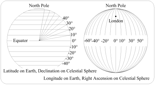
Lat/Long vs. Dec/RA
To define a position on Earth lines of latitude & longitude, as shown in the drawing, are used. For any particular point on Earth, the longitude line is called its Meridian. Latitude is the distance from the equator towards one of the poles, measured as shown. Longitude is the distance around the Earth, also measured as shown On the celestial sphere the latitude is called Declination & is similarly measured (from the celestial equator), but the longitude is called the Right Ascension, RA, & is subtly different. These are Equatorial coordinates.
In the drawing the observer is shown on the surface of the Earth. When he discovers a star he records its declination & the time that the star is on his zenith (crossing his meridian). The RA is measured from the meridian of the vernal equinox eastward, so his RA, at the recorded time, must be ascertained. Then that is the star's RA.
If the intervals between successive noons are measured, a complicated pattern of differences between these intervals emerges.
These differences have two causes - first, because the Earth moves along its orbit as it rotates, it must rotate slightly more than one rotation between successive noons, & second, the Earth's orbit is elliptical and the Earth moves faster along its orbit when closer to the Sun. An average of the intervals is called the Mean Solar Day, & this is the day in everyday life.
Over a year the Earth makes one orbit taking 365.242 198 79 solar days, but it doesn't rotate 365... times; it rotates 366... times. So the time, in mean solar days, is 365... / 366... = 23h 56m 4.091s. This is one Sidereal Day, which gives Apparent Sidereal Time.
The Earth's movement in the solar system is mostly an ellipse around the Sun. However, all the things in the system have a gravitational effect. The most effective are the Sun, the Moon & Jupiter. The largest effects are the movements of the Earth's axis relative to the stars.
Next page: Astronomy 4
Previous page: Astronomy 2
Howard's Stuff Index
Back to Pigeon's Nest
Be kind to pigeons